"We are all dead" were not the words of Priscillian when he asserted that we humans actually live in Hell. Those were words written down in the vaste loneliness of north Greenland by Jørgen Brønlund when he realised that he and his two companions were condemned to die. I know I am putting a foot out of my favourite century (the XIX) but, please, forgive me. I am only placing my toes in the first years of it and I hope you all will agree with me that this will be justified enough.
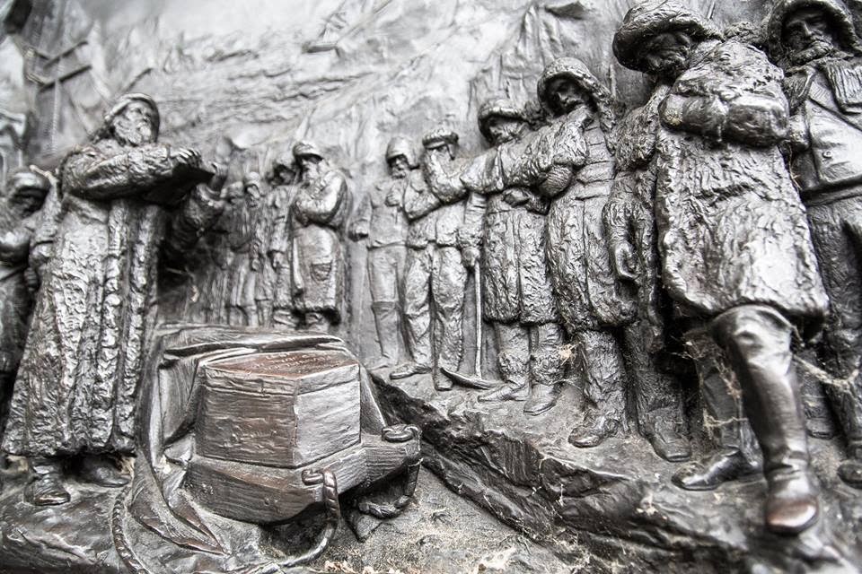
The tragic end of Jørgen Brønlund and his two mates is very similar in more than one sense to the Scott´s one though much less known. He died while returning from the furthest point reached, rescue parties were very close to find them when they still were alive and his journal was found perfectily legible together with his body. The tone of his last entry is much colder and sober than the tone used by Scott and allow us to understand perfectly well how Inuit people confront the death. There are, however, several factors about their end which should bring to our minds other existing parallelisms with events which could have taken place during the retreat of the men of the Franklin expedition.
Jørgen was a man of Inuit ascendency and was the interpreter, dog-team leader and the man responsible of writting the diary of the Denmark Northeast Greenland expedition which should last from 1906 to 1908. While other nations were struggling and vanishing in the arctic archipielago or in Hudson Bay the Danish people, like a stubborn army of ants, had been exploring and mapping that great island, which it seems was once indeed green, for at least 170 years. However, in spite of this close siege, there still remained few areas of the shoreline to be discovered and properly mapped.
Three men died during that expedition, and they died mainly due to the inaccuracy of the geographical data collected by Peary during his previous attempts to reach the North Pole from the north tip of Greenland some years before. Three men, Mylius-Erichsen, Hoeg Hagen and Jørgen, died because they were forced to follow coast lines which trend to the east instead of to the west, as their maps indicated, and were distracted by unexpected long fjords which cut their way and which didn´t appear on their maps. Those distractions obliged them to spend a not wanted summer in the north and therefore to slow radically their pace. The strategy followed for overland expeditions is exactly the opposite to the strategy followed by naval expeditions. Where exploration ships look forward the summer to advance among ice free waters, explorers who use sledges, prefer the snowy and smooth landscapes to fly hundreds if not thousands of kilometers at a high rythm. The arrival of the summer for a sledge party at hundreds of kilometers from their base camp could mean death.
The dangers hidden in the arctic are numerous, perhaps the most unpredictable of all of them could be an inoffensive map. Yes, a single, simply and plain map. Maps with mistakes, even with minor ones, could kill hundreds of people on those times. Wrong maps unveiled themselves as unexpected, inexorable and improbable murderers.
As it happened with the errors comitted by Peary on drawing his maps, the fictional Poctes bay, a bay which had been perceived, or better said, intuited by James C. Ross and by Dease and Simpson during their respective expeditions, could have meant the death for a group of men from the Franklin expedition if not responsible of the death of the whole group.
If Poctes bay had existed some men could have travelled eastwards over its istmus to the mainland and from then towards the Inuit settlements of Repulse bay, as if it that istmus were a yellow brick road or just a providential gangway placed there to allow them their salvation. As it didn't actually exist perhaps some men were stopped in the east coast of King William island after having abandoned their boats with the hope of being able to find a passage of land to the east.
On the other hand, if Poctes Bay hadn´t existed on that map the Erebus and Terror could have made their way south by the safer and usually ice free east side of King William Island and have therefore completed, perhaps safely, the route of the Northwest passage.
So, the same as a proffesional killer who wants to be sure his victim is not going to stand up again, that dotted line which marked the (darn it) 'likely' existence of that itsmus on the map, could have condemned the expedition not merely in a single way but, as we have seen, in two different ones.
But let´s return to the eternally frozen shores of east Greenland. Twenty eight men composed the expedition which was called the Danmark Expedition to Greenland´s Northeast coast 1906-1908. On board of an appropiatelly called ship "Danmark" the expedition wintered about the latitude 77º in a land called Germania. From there several sledges trips were dispatched. Several to say something, in fact two hundred sledge trips were sent in two years, TWO HUNDRED. The ship carried one hundred dogs on board. You can picture the situation. This herd almost provoked the collapse of the expedition when during the outward journey all of them escaped and wandered freely over the decks for some time eating and destroying everything at sight with no restrictions.
It is remarkable to mention that one of these sledge parties performed a distance of 315 km in only five days, that means an impressive rate of 63 km a day, an incredible distance. At the sight of those numbers one have to wonder if Peary could have really reached the pole after all. mmmm! Just a thought.
The summer fell over those poor men forcing them to walk over stony and bare ground destroying their boots and doing impossible the use of sledges. They tried to come back to the ship retracing southward the route that they have been following north that previous spring but the shores of Greenland were this time free of ice and presented for them impassable waters. The east coast of greenland is treacherous and capricious, she shows herself sometimes free of ice and sometimes blocked with a thick layer of ice. It was in front of those shores where Franklin was repudiated by the ice on his attempt towards the North Pole. If you analize the map below you will notice how all the expeditions which wandered close to this area were unable to go north of Cape Bismark.
That was the end. That fact forced them to go inland and walk over the ice with their half destroyed shoes. The lack of game and their feet frozen to the bone made them to stop and die of hunger and cold while trying to reach safety. The Koch party had travelled meanwhile over 2.000 km, the three men had a hard time to return home but they survived. You can read the whole story in the chapter dedicated to it here.
The tragic end of Jørgen Brønlund and his two mates is very similar in more than one sense to the Scott´s one though much less known. He died while returning from the furthest point reached, rescue parties were very close to find them when they still were alive and his journal was found perfectily legible together with his body. The tone of his last entry is much colder and sober than the tone used by Scott and allow us to understand perfectly well how Inuit people confront the death. There are, however, several factors about their end which should bring to our minds other existing parallelisms with events which could have taken place during the retreat of the men of the Franklin expedition.
Jørgen was a man of Inuit ascendency and was the interpreter, dog-team leader and the man responsible of writting the diary of the Denmark Northeast Greenland expedition which should last from 1906 to 1908. While other nations were struggling and vanishing in the arctic archipielago or in Hudson Bay the Danish people, like a stubborn army of ants, had been exploring and mapping that great island, which it seems was once indeed green, for at least 170 years. However, in spite of this close siege, there still remained few areas of the shoreline to be discovered and properly mapped.
 |
| Jørgen Brønlund http://en.wikipedia.org/wiki/File:J%C3%B8rgen_Br%C3%B8nlund.jpg |
The dangers hidden in the arctic are numerous, perhaps the most unpredictable of all of them could be an inoffensive map. Yes, a single, simply and plain map. Maps with mistakes, even with minor ones, could kill hundreds of people on those times. Wrong maps unveiled themselves as unexpected, inexorable and improbable murderers.
As it happened with the errors comitted by Peary on drawing his maps, the fictional Poctes bay, a bay which had been perceived, or better said, intuited by James C. Ross and by Dease and Simpson during their respective expeditions, could have meant the death for a group of men from the Franklin expedition if not responsible of the death of the whole group.
 |
| From: Narrative of a second voyage in search of a North-west passage |
On the other hand, if Poctes Bay hadn´t existed on that map the Erebus and Terror could have made their way south by the safer and usually ice free east side of King William Island and have therefore completed, perhaps safely, the route of the Northwest passage.
So, the same as a proffesional killer who wants to be sure his victim is not going to stand up again, that dotted line which marked the (darn it) 'likely' existence of that itsmus on the map, could have condemned the expedition not merely in a single way but, as we have seen, in two different ones.
But let´s return to the eternally frozen shores of east Greenland. Twenty eight men composed the expedition which was called the Danmark Expedition to Greenland´s Northeast coast 1906-1908. On board of an appropiatelly called ship "Danmark" the expedition wintered about the latitude 77º in a land called Germania. From there several sledges trips were dispatched. Several to say something, in fact two hundred sledge trips were sent in two years, TWO HUNDRED. The ship carried one hundred dogs on board. You can picture the situation. This herd almost provoked the collapse of the expedition when during the outward journey all of them escaped and wandered freely over the decks for some time eating and destroying everything at sight with no restrictions.
It is remarkable to mention that one of these sledge parties performed a distance of 315 km in only five days, that means an impressive rate of 63 km a day, an incredible distance. At the sight of those numbers one have to wonder if Peary could have really reached the pole after all. mmmm! Just a thought.
The longest journey and the biggest party included ten sledges. Its target was going north to map the blank areas. It was performed at the usual style of sending back supportting teams and deploying depots all over the way. One of the participants of one of the teams which was sent back was the famous Alfred Wegener. Six men reached the northeastern point in Greenland. It was planned that the party would split in two teams. One led by Mylius had to go west and the other led by Koch had to travel north towards Kap Birdgman, one of the points discovered by Peary.
Both parties met again at the end of May south of the Independence Fjord after months of arduous work. They planned at first to come back together towards the ships but, as the west party hadn´t been able to fulfill its target after having found some unexpected obstacles, a day after, in spite of the advanced season, Mylius splitted again travelling westward towards Navy Klippe in an attempt to finish the job.
The summer fell over those poor men forcing them to walk over stony and bare ground destroying their boots and doing impossible the use of sledges. They tried to come back to the ship retracing southward the route that they have been following north that previous spring but the shores of Greenland were this time free of ice and presented for them impassable waters. The east coast of greenland is treacherous and capricious, she shows herself sometimes free of ice and sometimes blocked with a thick layer of ice. It was in front of those shores where Franklin was repudiated by the ice on his attempt towards the North Pole. If you analize the map below you will notice how all the expeditions which wandered close to this area were unable to go north of Cape Bismark.
That was the end. That fact forced them to go inland and walk over the ice with their half destroyed shoes. The lack of game and their feet frozen to the bone made them to stop and die of hunger and cold while trying to reach safety. The Koch party had travelled meanwhile over 2.000 km, the three men had a hard time to return home but they survived. You can read the whole story in the chapter dedicated to it here.
 |
| Arctic regions : with the tracks of search parties and the progress of discovery, compiled from the latest information / compiled by A.C. Roberts ; lithography by Gr. Noetzel. |
The Mylius party perished while trying to reach one of the depots deployed during the outward journey, the Lambert depot. Mylius and Hogen died before reaching it and their bodies were not found. Only Jorgen found the strength enough to reach a point where he knew his body and diaries would be found. His will drag him to this place beyond human limits.
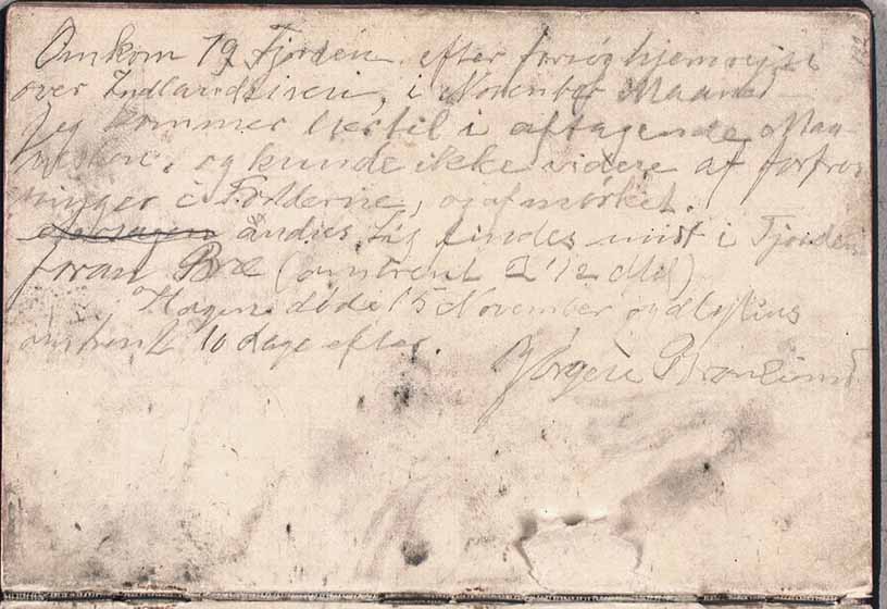
His last entry says:
“Died 77 Fiord after attempt return home across the inland ice, in the month of November. I come here by waning moonlight, and could no more from frostbitten feet, and because of the darkness. The bodies of others are in the middle of the fiord in front of glacier (c. 2½ miles). Hagen died 15 November and Mylius about 10 days later. Jørgen Brønlund”.
 |
| http://thewe.cc/thewei/&/poles/arctic/danmark_expedition.jpg |
This journal and other records, left under cairns during their desperate struggle, were brought home and from them we know now how those poor men ended. As always happens under these circunstances, they died surrounded by misery, cold, hunger and pain.
This finding is less known but it increases the list of journals that have been found in polar regions which have brought us vividly the tragic death suffered by their writers. Let´s review them: Scott´s journal was found months after his death, the journal of Solomon Andree was found about 30 years after his death also close to his remains, pages of the journal of one of the men which vanished in the arctic from the Brussilov expedition were found in the arctic one hundred years after their deaths, the journal of the commander DeLong from the Jeannete expedition was also found with him a year after they died in the Delta of the Lena.
I know there are more paralellisms with the last Scott´s expedition than with the Franklin expedition but the effort of this man to reach a point where he knew could be surely found, should make us reflect that the men of the Franklin expedition SHOULD have left a more complete record somewhere in King William Island, in a place where it would undoubtedly be found. I can´t think in any other better place than the Victory Point, the James C. Ross North Magnetic Pole point or the Dease and Simpson cairn in Cape Herchel. Thorough archaeological excavations shoud be launch to those three areas or to those significant gegraphical points we know were already known in 1845.
To end the story, it has been a happy and fascinating coincidence discovering that Tom Kjeldsen have drawn the whole route followed by this expedition in an amazing detail, so, if you are lost among all these names and geographical features which have been described above you could find here a detailed Google Earth file which will allow you to find your way back safely home. Besides that discovery has given me the idea of publishing my "permanently at work "botched job in the Google community when I finished it.
No hay comentarios:
Publicar un comentario